Forecast for Sunday, July 15, 2018

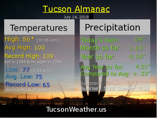
Yesterday’s high of 86 was a new record low high temperature for the date! The light rain in the late morning and cloud cover throughout the day put a damper on storms, but most of us got in on some light rain (half the calories of our regular rain). The airport picked up .08″ which isn’t nothing.

Showers and thunderstorms moving through Oro Valley as I write this just before 5:00 a.m. with more activity to our north and northwest. Look for showers and storms to move through the area this morning (you think?!). It’s possible that our morning rain may put the breaks on our afternoon/evening chances, but maybe not. Time will tell (just being honest). Today’s high near 92. Enjoy this morning’s showers and hope we can recharge the atmosphere for more later today.

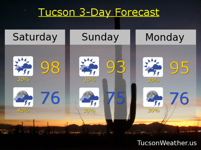
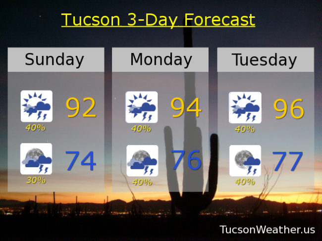
Showers and storms possible tonight with a low in the mid 70s.

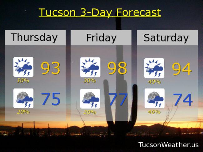
Scattered storms tomorrow and tomorrow night with a high in the mid 90s. 40% chance Tuesday too with a high in the mid 90s.

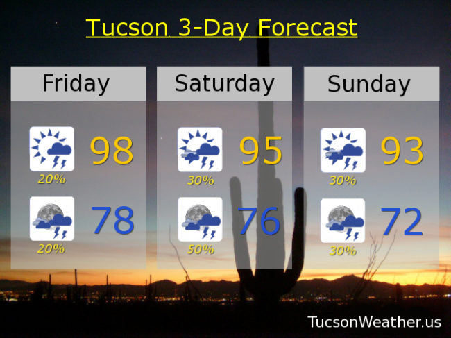
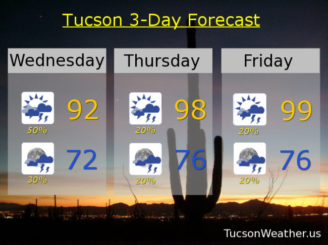
High pressure building in just to our east and close enough to inhibit storms chances, but still a chance. Warmer too. 20% Wednesday mid 90s. 10% Thursday upper 90s. 10% Friday 103ish. 10% Saturday 106! Viva Monsoon 2018!

Forecast for Saturday, July 14, 2018

A day today similar to yesterday. Round and round the thunderstorms go. Exactly where they’ll hit, nobody knows. Hopefully near you! Upper 90s again today with some clearing skies this morning. Storms will have no problem forming over the mountains, but with a weak steering flow they’ll have a tough time drifting over valley locations. However, all is not lost. Just like yesterday we should see some storms pop up just about anywhere. Where they do there will be a potential for heavy rainfall.

Storm chances continue tonight mainly before midnight. Again with locally heavy rain and a low in the mid 70s.

Scattered storms tomorrow low 90s. 30% chance Monday, Tuesday and Wednesday mid 90s. High pressure forming closer to us late in the week with less storms but still a chance. Warmer too. 10% chance Thursday near 100ish. 20% Friday 102. Viva Monsoon 2018!

Forecast for Friday, July 13, 2018

Heavy rain for some yesterday! Hopefully near you. The south side and downtown got drenched. Also another brief heavy shower here in southern Oro Valley around 6:30 last night. Chance for storms go down a bit today, but some of the storms that form will have locally heavy rainfall once again. Plenty of sunshine later this morning into the afternoon hours to help the cause. Storms will easily form on the mountains late morning or early afternoon. Weak steering winds will likely keep them there, but again, isolated storms are possible just about anywhere in the area this afternoon/evening. Today’s high in the upper 90s.

Isolated storms ending tonight with a low in the upper 70s.

Storm chances ramp back up tomorrow with a 30% chance tomorrow and a 50% chance by evening and a high in the mid 90s.

Scattered storms Sunday low 90s. 30% Monday mid 90s. 20% Tuesday and Wednesday upper 90s. 10% Thursday near 100ish. Viva Monsoon 2018!

Forecast for Thursday, July 12, 2018

Busted! Yesterday’s promise of scattered storms with heavy rain really didn’t come true. So what happened? We had a few storms in the late morning that spread clouds across the area shutting off our surface heating. As a result we lost our instability, so almost no storms. We only hit 88 for a high, so that was “cool”.

We make another run at it today. If we can manage enough sunshine today we should see scattered storms, some with heavy rain, hopefully near you! A disturbance over the area should help as well. The airport already picked up a quarter inch of rain from 3:10 this morning until 3:30! That shower moved over parts of the east side. Let’s add to those totals today, shall we?! High in the low 90s.

What storms we get should end by before midnight tonight with a low in the mid 70s.

Scattered storms possible tomorrow with a high in the upper 90s. Good chance for storms Saturday with a high in the mid 90s. 30% chance for storms Sunday and Monday with highs in the mid to upper 90s respectively. 20% chance Tuesday and Wednesday near 100. Viva Monsoon 2018!

Forecast for Wednesday, July 11, 2018

Here we go again! Very active day yesterday in Marana and Oro Valley with some areas getting 2 to 2 1/2 inches of rain! Who knew that we would put the rain in train with the storm causing a train derailment in Marana. Yikes! A few water rescues too, but the good news is no one got hurt. Please continue to enjoy Monsoon 2018 responsibly as we are looking at another round of storms, some with heavy rain today. Already breaks in the clouds this morning and if we see sunshine that will help storms to get going starting this afternoon. Additionally we have a disturbance in the force riding northward into the area from Mexico this afternoon to help the cause. Very rich moisture in place, so we will likely see heavy rain again today in some areas and maybe we’ll send another haboob to Phoenix. Today’s high in the low 90s should occur in the early afternoon before the rains get going.

Scattered showers this evening ending before midnight with a low in the low 70s.

Rain mainly on the wane Thursday and Friday but still a few storms about with highs in the upper 90s.

Storm chances ramp back up this weekend with a low headed our way. 40% chance Saturday upper 90s. 30% Sunday low 90s. 30% Monday mid 90s. 30% Tuesday upper 90s. Viva Monsoon 2018!