Forecast for Wednesday, July 25, 2018

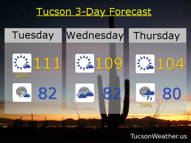
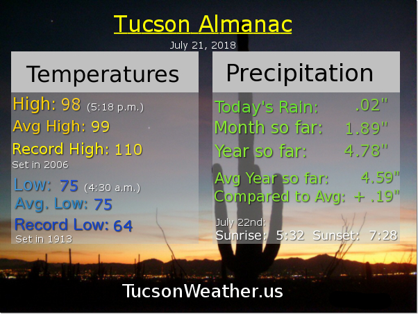
Congratulations! You survived the record heat yesterday. 112 was just two degrees from the all-time July record of 114. Yikes! The good news is the dewpoint fell into the low 40s yesterday so 112 felt like 112 with a relative humidity of just 9%. One more day of excessive heat with the EXCESSIVE HEAT WARNING expiring at 8:00 tonight. 109 this afternoon would tie the record if it comes exactly true. Be cool!

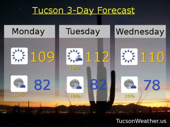
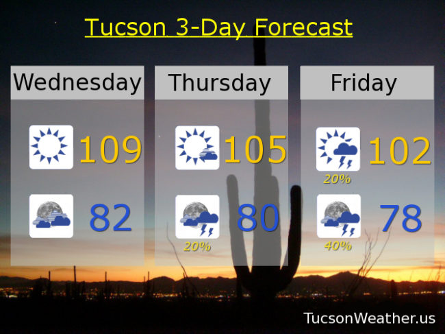
Still kinda hot the next couple of days with 105ish tomorrow and 102 Friday. As the high pressure moves to the NW moisture will be increasing and so will the chance for storms. 20% chance for storms as early as tomorrow night. 20% Friday and 40% Friday night!

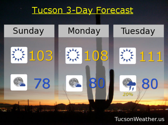
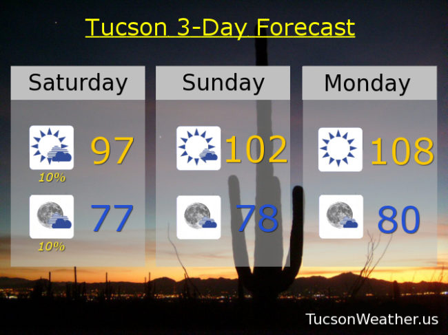
Scattered storms continue this weekend into next week as temperatures fall to near our average of 98 for this time of year. 20% Saturday and 30% Saturday night 98. 20% Sunday and 30% Sunday night 97. 20% Monday and 40% Monday night near 100. 30% Tuesday 100.

Forecast for Tuesday, July 24, 2018

EXCESSIVE HEAT WARNING continues until tomorrow night at 8:00, so be warned, the heat will be excessive. A couple storms popping up this morning near Catalina to near Oracle. Nice light show from the deck from about 3:30 until after 4:00. Another isolated storm right now (6:10 a.m.) over the Rincons. We’ll keep isolated storms in the forecast today, but the weather headline is the head. High pressure over SE Arizona basically trying to kill us. Today’s forecast high of 111 will break the daily record of 109 and is just 3 degrees shy of the all-time record high for July. Let’s hope it doesn’t come to that! Tonight any stray storms that form will dissolve leaving partly cloudy skies and a not so low low in the low 80s.

109 tomorrow will tie the record high if it comes exactly true.

High pressure moving to the NW will open the door for a return of deeper moisture. That means a better chance for storms starting Thursday evening and increasing this weekend. Thursday’s high 104ish. 20% chance for storms Friday 101. 30% Saturday 98. 20% Sunday upper 90s. 30% Monday upper 90s. Be cool!

Forecast for Monday, July 23, 2018

Pretty nice on the deck this morning with an amazing sunrise! Don’t fall for it. It’s a trap! EXCESSIVE HEAT WARNING in effect starting at 10:00 this morning and lasting until Wednesday at 8:00 p.m. Be warned, the heat will be excessive! 109 is today’s record high and we are expected to be right there. Tomorrow’s record of 109 is gonna fall with an expected high of a scorching 112! Wednesday’s record high, also 109, is also expected to fall with an expected high of 110ish. A bit drier than last week with dewpoints in the mid 50s, but still enough moisture for a very slight chance for a storm in the evenings the next few days.

Then our fortunes start to turn as Monsoon 2018 roars back into SE Arizona! A moisture surge from the south overnight Wednesday into Thursday morning will give us a better chance for storms. The flow becomes SEasterly by the weekend with an even better chance for storms, even in the overnight hours. Hang in there! This heat too shall pass.

Sunny today 109. 112 tomorrow. 110 Wednesday. 10% Thursday 104. 20% Friday 99. 30% Saturday 98. 40% Sunday upper 90s.

Forecast for Sunday, July 22, 2018

Good day to plan a trip to the Grand Canyon or Colorado or something. Just make sure you don’t come back until Thursday or so. The rest of us will have to deal. High pressure building in and it means business. EXCESSIVE HEAT WARNING for Monday and Tuesday and Wednesday will probably be added soon. Record highs for those three days is 109. We’ll be really close Monday and Wednesday and Tuesday should be an easy win. Even 103 today is 5 degrees warmer than yesterday. Just make sure you drink plenty of water lest you burst into flames. Be cool!

Sunny today near 103. Mostly clear tonight upper 70s.

108ish tomorrow. 111 Tuesday! 20% chance of sweet relief from a storm or two Tuesday night near 80 for a low. 108 Wednesday with a 20% chance Wednesday night. 20% Thursday 102. 20% Friday 99. 40% Saturday 98ish.

Forecast for Saturday, July 21, 2018

So nice out on the deck this morning! A cool breeze after the overnight rain. It looks like the NW side was the big winner once again. Catalina State Park picked up 1.65″ inches of rain! Oro Valley anywhere from a quarter inch to three-quarters. The east side got in on the action too with up to a half inch of rain. The airport picked up just .02″ which isn’t zero at least. Yesterday afternoon got crazy in Corona de Tucson with a severe storm that dumped 1″ hail and a bunch of rain. Thanx to Tina Wilson for sharing dramatic video on the FB page!

Just a slight chance for rain this afternoon and evening as we look to Monday, Tuesday and Wednesday for some big time heat. The National Weather Service has issued an EXCESSIVE HEAT WARNING for Monday and Tuesday, so be warned, the heat will be excessive! It will probably be expanded into Wednesday, so there’s that. High pressure will move away as next week wears on and we’ll see the return of Monsoon 2018. Until then, gird your loins!

Becoming mostly sunny today with just a 10% chance for showers or a storm and a high in the upper 90s.

A 10% chance tonight with partly cloudy skies and a low in the upper 70s.

Mostly sunny tomorrow 102ish. Sunny Monday 108. 110 Tuesday! 108 Wednesday. 10% chance Thursday 102. 20% Friday 99.