Forecast for Saturday, August 4, 2018

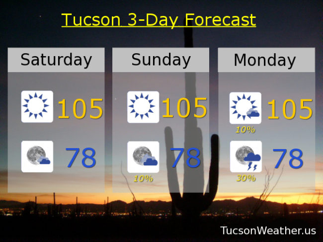
I can’t even. I have no words. Monsoon 2018 what are you thinking? EXCESSIVE HEAT WATCH for Sunday starting at 10:00 a.m. until Monday night at 8:00? Really? Really. High pressure moving over our head suppressing storm chances and bringing the heat. But I thought Excessive Heat was defined in our area with temperatures of 108 and above? The forecast for Sunday and Monday “only” calls for 105. Yeah, well, moisture trapped under the high will make it feel like 108ish. So much for a dry heat! At least storm chances return to the forecast Monday night  with isolated storms back in the forecast the rest of the week as the high retreats northward. We will rebuild!

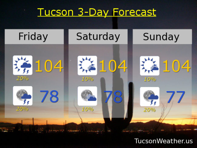
Mostly sunny today with a high near 105. Partly cloudy tonight upper 70s.

Hot and humid tomorrow with a high near 105 feeling hotter. 10% chance for a storm tomorrow evening low in the upper 70s.

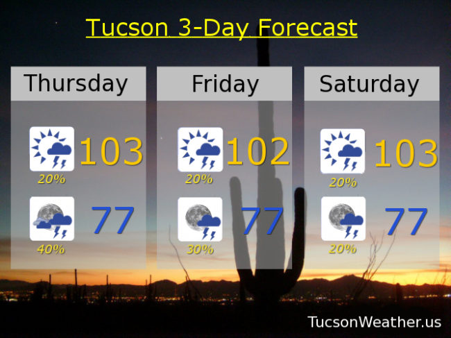
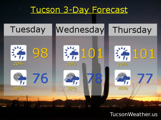
10%/30% Monday 105 with a 108ish feels. 10%/20% Tuesday 103. 10%/20% Wednesday 101. 10%/20% Thursday 100. 20% Friday 98.

Forecast for Friday, August 3, 2018

It’s Friiidaaay!!!

Big storms yesterday with heavy rain, but west of Tucson. One near Casa Grande blew a bunch of dust across I-10. That doesn’t sound like a bunch of fun. Scattered storms across the Phoenix area too along with dust. Meanwhile back at the ranch. The rumors of locally heavy rainfall in the metro were greatly exaggerated. We hit a high of 105! Hot and humid without the sweet relief of any showers. The break in the Monsoon should continue through the weekend into early next week. High pressure now to our SW and will be making it’s way toward the Four Corners. As it moves across our area it’ll be tough, but not impossible, to get a few storms going. On the hot side too along with some humidity. Joy!

Mostly sunny today with a 20% chance for an isolated storm or two and a high near 104.

Partly cloudy tonight with a slight chance for a storm before midnight and a low in the upper 70s.

Just a 10% chance for storms tomorrow and Sunday 104ish. 10%/30% Monday 104. 10%/20% Tuesday 102. 10%/20% Wednesday 101. 10% Thursday 101.

Forecast for Thursday, August 2, 2018

Viva Monsoon 2018! Widespread heavy rain last night. Vivid lightning. Strong damaging winds. Many folks who haven’t seen a lot of rain this Monsoon did some catching up last night. .26″ at the airport to get us on the scoreboard for the month of August on day one!

Could be another active day/evening. Last night’s activity has stabilized the air somewhat so probably a later start to activity today after the sunshine and subsequent heat recharges the atmosphere. Today’s high near 103. Slow moving storms and lots of moisture could lead to flash flooding with some of the storms tonight. Tonight’s low in the upper 70s. Please enjoy Monsoon 2018 responsibly.

Isolated to scattered storms tomorrow afternoon/evening with a high near 102ish. Isolated storms this weekend with highs both days near 103. 10%/30% Monday 102. 10%/20% Tuesday 102. 20% Wednesday 101.

Forecast for Wednesday, August 1, 2018

Thanx for the memories July, 2018. For the NW and east side you pretty much rocked! Even the airport finishing July right at average for rainfall for the month. If you are waiting to catch up, we still have August and September of Monsoon 2018 remaining. Keep hope alive! Viva Monsoon 2018!

After taking a personal day yesterday (who approved that request?) Monsoon is expected to return today with isolated to scattered afternoon and evening storms, hopefully near you! Today’s high near 102 and tonight’s low near 78.

A 20% chance for storms tomorrow afternoon and a 40% chance tomorrow night with a high near 101ish. 20%/30% Friday 99. Mostly sunny Saturday with a slight chance for evening storms 101. 20%/30% Sunday 100. 10%/40% Monday 99. 20% Tuesday 99.

Forecast for Tuesday, July 31, 2018

Monsoon 2018 roared last night! The Foothills was hit hard with at least one report of tree damage and over 2″ of rain!  Midtown got in on the act as well. A couple places that have been missing out finally participating in Monsoon 2018. Not as much activity expected today. Yesterday’s storms have sapped the atmosphere of some of the energy needed for widespread activity. Still, with plenty of moisture around and lots of sunshine we could see a few storms this afternoon and evening, hopefully near you! High pressure in the NW part of the state slowly moving to the Four Corners by the weekend will keep us in daily storm chances into next week. Viva Monsoon 2018!

Becoming mostly sunny today with isolated storms possible this afternoon and scattered storms perhaps this evening. Today’s high in the upper 90s. Low tonight in the mid 70s.

20% chance for storms tomorrow afternoon/30% tomorrow night high near 101. 20%/40% Thursday 101. 20%/30% Friday 100ish. 20%/30% Saturday 101. 20%/30% Sunday 99. 30% Monday 98.