Forecast for Thursday, August 9, 2018

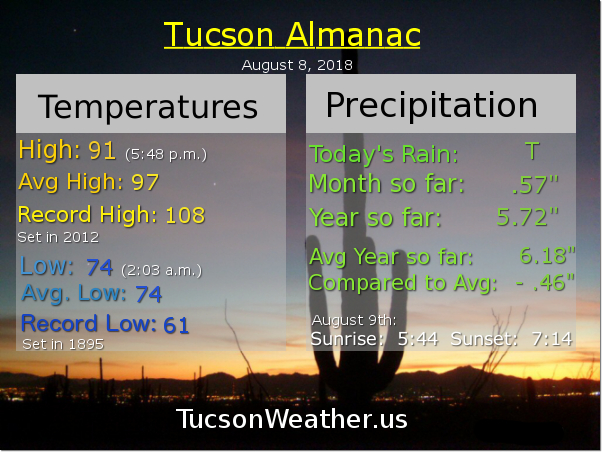
Viva Monsoon 2018! Storms in the area around 10:00 last night, hopefully near you. A decent light show to my north as a storm formed briefly over the OV, but no rain for me on the south side of our little burb. Lather, rinse, repeat into the weekend as we are now in an active Monsoon pattern.

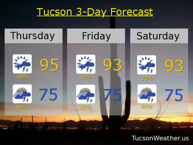
Easterly flow across the area with tons of moisture in place. Storms should form closer to the Metro this afternoon and drift in from the east for potentially an earlier start today. Locally heavy rainfall is possible with some of these storms and maybe some blowing dust for the usual areas. High around 95ish. Mostly cloudy tonight with scattered storms into the night with a low near 75.

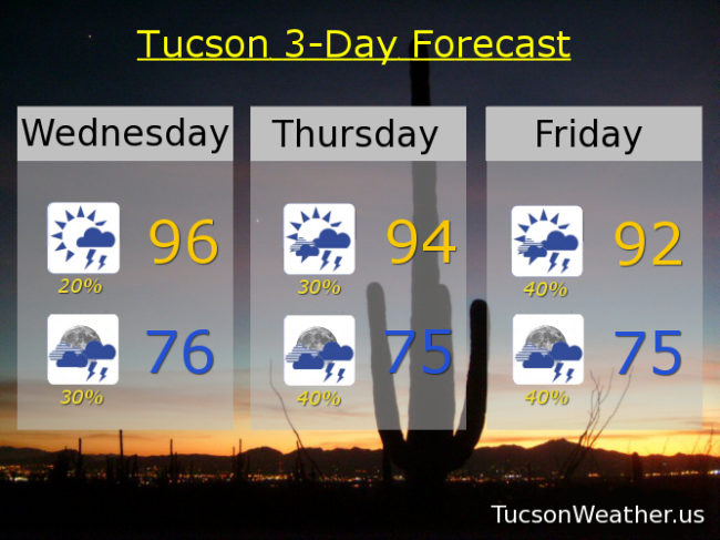
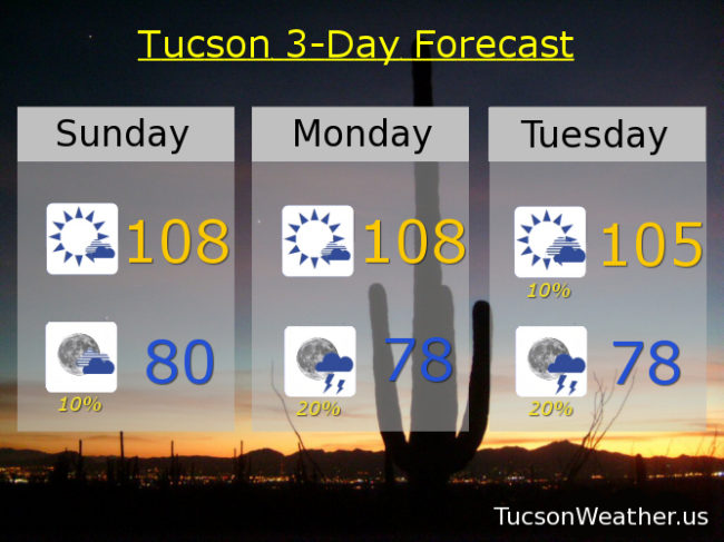
Partly sunny tomorrow with a 40% chance for storms and a high in the mid 90s. 50% chance for storms tomorrow night mid 70s. 30%/40% Saturday low 90s. 20%/30% Sunday upper 90s. 20%/20% Monday, Tuesday and Wednesday upper 90s.

Forecast for Wednesday, August 8, 2018

Welcome back Monsoon 2018! .26″ at the airport adding to our totals. That was fun last night, although I got skunked here in southern Oro Valley. I know how many of you feel when the OV was getting soaked and many of you were being left out. It’s like Monsoon is going on a date with all your friends and you have to watch from across town. But when Monsoon goes out with us again all is forgiven! We hug and kiss her and beg her not to leave. Looks like we have a date tonight. I can’t wait!

Day to day Monsoon activity tough to call. Computer models originally saying prime time would be tonight and Thursday morning now saying Thursday night and Friday. Some models are saying we quiet down a bit next week, but one model saying not so fast. Dewpoints in the mid 60s this morning so lots of moisture in place. Looks like a good chance for scattered afternoon and evening storms into the weekend and perhaps beyond. Viva Monsoon 2018!

Mostly sunny today with a chance for storms this afternoon and a high near 96. Mostly cloudy tonight with a better chance for storms and a low in the mid 70s.

Partly sunny tomorrow and mostly cloudy tomorrow night. 30%/40% 94ish. 40%/40% Friday low 90s. 30%/30% Saturday mid 90s. 20%/30% Sunday and Monday mid 90s. 20% Tuesday mid 90s.

Forecast for Tuesday, August 7, 2018

I had a weird dream that my cell phone woke me up with an EXCESSIVE HEAT WARNING warning at 3:00 a.m. Then I woke up and saw that it wasn’t a nightmare, it was true! Be warned. There will be excessive heat. Yesterday we tied the record high of 109. A couple of stray storms made it’s way across town last night, hopefully near you! The airport picked up .05″ which beats a swift kick (don’t ask me how I know that). Moisture is increasing across the area, so today’s expected high of 106 will be a bit uncomfortable. The good news is storms should fire earlier today and by this evening more of us will have a chance of getting wet. Tonight’s low in the upper 70s.

High pressure moving northward with an inverted trough riding our way from the east. Lots of moisture including a couple of hurricanes south of Baja California that will help push more our way. It all adds up to what should be an active week for Monsoon 2018! Early indications are that prime time will be tomorrow night and storm chances remain good into the weekend!

Partly sunny tomorrow with a 30% chance for storms and a high near 99ish. Mostly cloudy tomorrow night with a 50% chance for storms mid 70s. 30%/40% Thursday low 90s. 20%/40% Friday mid 90s. 30%/40% Saturday mid 90s, 20%/30% Sunday mid 90s. 20% Monday mid 90s.

Forecast for Monday, August 6, 2018

Must survive. One. More. Day. 107 yesterday meaning the record of 108 remains. Not quite excessive heat since that threshold is 108 in these parts. Still. 109 today, if it comes true, will tie the record set in 1995. I’m thinking we’ll be just shy, but still, an EXCESSIVE HEAT WARNING remains until 8:00 tonight.

The really good news is Monsoon 2018 is fixin’ to return to us! High pressure moving off to the north opening the door for more moisture by tomorrow afternoon. A couple of tropical systems south of Baja California will push a Gulf of California surge of moisture into southern Arizona. Add an inverted trough and storms should be firing starting tomorrow evening with daily activity expected through the weekend! Viva Monsoon 2018!

20% chance for storms tonight with a low near 80.

10% chance tomorrow near 104ish. 30% tomorrow night upper 70s. 20%/40% Wednesday 98. 20%/40% Thursday 96. 30%/50% Friday 95. 30%/40% Saturday 94. 20% Sunday 95.

Forecast for Sunday, August 5, 2018

Run to the hills! You know. Because it’s cooler up there. They don’t call it Summerhaven for nothin’! High pressure is large and in charge and bringin’ the heat. EXCESSIVE HEAT WARNING from 10:00 this morning until tomorrow night at 8:00. Be warned, the heat will be excessive. Please make sure you stay hydrated lest you burst into flames. Never leave living things unattended in the car (oven) and walking the dog on hot asphalt is just cruel.

Today’s expected high of 108 would tie the record last set in 2009. Enough moisture around for a chance of an isolated storm this evening! Hopefully one near you, but it’s just a slight chance with a low tomorrow morning near 80.

Tomorrow’s record high is 109. We’ll be close! with an expected high of 108. Again, enough moisture trapped under the high for a 20% chance of storms tomorrow evening and a low in the upper 70s.

Our fortunes begin to reverse themselves as the high moves to the north. A tropical system near Baja California may even get into the act! Slight chance for a storm Tuesday afternoon with a high near 105. 20% chance Tuesday night upper 80s. Slight chance for a storm Wednesday 102. Wednesday night looks very promising with a 40% chance for storms mid 70s. 10%/30% Thursday 99ish. 20%/50% Friday 98. 30% Saturday mid 90s. Be cool!