Forecast for Tuesday, August 14, 2018

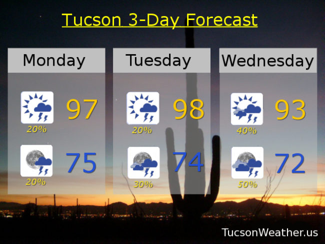
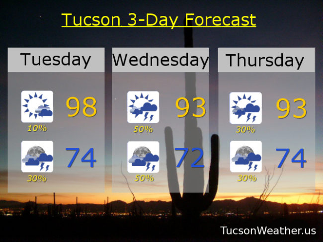
Well that was disappointing. Maybe there is something to this Monday the 13th thing! Nuthin’ but sunshine yesterday despite the Storm Prediction Center predicting a chance for severe storms. Sinking air with high pressure suppressed activity and we ended up with barely a cloud in the sky. That’s fixin’ to change today! High pressure has shifted a bit to the east and that should open the door for more moisture and the elimination of sinking air. Storms moving from the SE today, so forming on the mountains and to our south and east this afternoon and then moving our way by this evening. At least that’s the plan! So. 10% chance for storms in the Metro this afternoon and high near 98. Then a 30% chance for storms this evening/tonight with a low in the mid 70s.

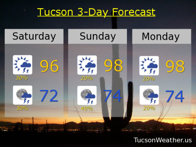
But wait. There’s more! An inverted trough moving out of Mexico into southern Arizona tomorrow and Thursday should give Monsoon 2018 some extra umpf. (umph?) 50% chance for storms Wednesday and Wednesday night with locally heavy rainfall and a high in the low 90s! 30% chance for storms Thursday and Thursday night low 90s. High pressure shifting back to the west calming “things” down a bit Friday into the weekend. 20%/30% Friday and Saturday upper 90s. 20%/20% Sunday and Monday upper 90s.

Forecast for Monday, August 13, 2018

A severe thunderstorm fell apart right before my eyes over Oro Valley last night. Big time rain last night across the southern part of town including Vail. You probably saw on the news that one person was killed on the south side when his car was swept away in a wash. Please. Enjoy Monsoon 2018 responsibly.

It is amazing on the deck this morning! Lots of sunshine should reload the atmosphere today for pretty much a repeat of yesterday. Storms forming over the White Mountains will make there way our way as the afternoon wears on for a chance of scattered storms this evening. Storms could form earlier mainly south and east of Tucson, but maybe one near you. Once again the Storm Prediction Center is saying we have a marginal threat for severe storms, so we could see a strong to severe storm or two this afternoon/evening. Tomorrow looks a lot like yesterday and today. Highs today and tomorrow in the upper 90s and lows in the mid 70s.

An uptick in activity Wednesday and Thursday as an inverted trough is forecast to move into southern Arizona out of Mexico. That will bring an increase of moisture as well as added lift for numerous storms perhaps lasting through the night Wednesday and Thursday nights! Heavy rainfall will be possible as well. Viva Monsoon 2018! Highs Wednesday and Thursday in the low 90s and lows in the low 70s.

Back to our “average” Monsoon activity Friday through the weekend with storm chances generally 20% to 30%. High Friday in the mid 90s. Upper 90s Saturday and Sunday.

Forecast for Sunday, August 12, 2018

Congratulations center of town. You did pretty well yesterday! I hope it didn’t put a damper on Second Saturday festivities downtown. Still. It’s nice to see a part of the Metro neglected by Monsoon 2018 receive some love. <3 It rained here in southern OV overnight, but skies have already cleared. Lots of sunshine today should reload the atmosphere for another round of storms this afternoon and evening. The Severe Storm Prediction Center even has us on the edge of a marginal risk for severe storms this afternoon! With a 20% chance for storms this afternoon and evening we probably won’t see widespread activity, but be aware that a storm or two may become severe with damaging winds and hail the biggest threats. Upper 90s for highs and mid 70s for lows through Tuesday with isolated to widely scattered afternoon and evening storms possible.

Storm chances ramp up big time Wednesday, and especially Wednesday night and Thursday! An inverted trough should give us the lift we need for an upswing in Monsoon 2018. 30%/50% Wednesday mid 90s/low 70s. 40%/30% Thursday low 90s. 30%/30% Friday mid 90s. 30% Saturday upper 90s. Viva Monsoon 2018!

Forecast for Saturday, August 11, 2018

That’s what happens when you treat your girl right. She showers you with storms and small hail! If Monsoon 2018 ain’t happy, ain’t nobody happy. Not as much showering us with storms today with a bit of drying in the upper levels of the atmosphere, but still an afternoon of excitement headed our way with the fun lasting into the evening.  Tomorrow looks even better as the drier air retreats.  High pressure nosing into our business a bit Monday and Tuesday will slow down storms some, but we shouldn’t be left completely high and dry.  Storm chances look really good Wednesday night/Thursday as moisture increases again and a disturbance in the force is expected to invade from Mexico. We love you Monsoon 2018! Don’t ever leave!

Mostly sunny today with scattered afternoon and evening storms and a high near 96. Low in the low 70s.

Mostly sunny tomorrow with a 20%/40% chance for storms 98ish. 20%/20% Monday 98. 10%/20% Tuesday 98. 20%/30% Wednesday mid 90s. 30%/20% Thursday low 90s. 30% Friday mid 90s.

Forecast for Friday, August 10, 2018

Showers overnight with a bulls eye of nearly 2″ in Marana! A few hundredths at the airport. Hopefully some near you! Lingering showers in the area even as I type at 6:30. Dewpoint is 67, so way up there. Looks like another good chance for storms by tonight. Activity forming in the White Mountains first, moving to the SW as the afternoon and evening progresses. 40% chance for storms this afternoon and 50% tonight. Viva Monsoon 2018! Storm chances fade a bit by Sunday into early next week, but still a 20% to 30% chance for scattered afternoon and evening storms. Chances ramp back up mid week and for the foreseeable future thereafter! Looks like a good Monsoon August is shaping up, at least in theory. Hopefully it will translate into real life! Of course we’ll keep you posted.

Becoming partly sunny today with a 40% chance for afternoon storms and a 50% chance tonight. Some storms with locally heavy rainfall possible. High 94, low 74.

Partly sunny tomorrow with a 30% chance for afternoon and evening storms mid 90s. Partly cloudy Sunday 20%/30% chance for storms upper 90s. 20%/20% Monday 98ish. 20%/20% Tuesday 99. 30%/30% Wednesday upper 90s. 30% Thursday mid 90s.