Forecast for Sunday, August 19, 2018

I have good news! Monsoon 2018 just sent a note via the computer models saying she is returning to us soon! Probably by Tuesday, maybe even Monday night. As we await the return of our MIA metaphor it’ll be hot and dry. 103 today. 104 tomorrow but with a slight chance for an isolated storm or two! Tuesday looking pretty good as high pressure that is now to our west that has pushed our Monsoon moisture south, will be moving into New Mexico to usher Monsoon moisture back north! Scattered storms back in the forecast Tuesday with a high near 101. 30%/50% Wednesday! 97ish. 30%/30% Thursday 95. 20%/20% Friday 95. 20% Saturday 97. Viva Monsoon! (hopefully soon)

Forecast for Saturday, August 18, 2018

Everybody into the pool! Monsoon 2018 is taking a break. I mean. Not that she hasn’t been slacking in her duties lately anyway, but now the forecast reflects our unfortunate reality. High pressure will be building in. Moisture is leaving. It’s gonna be hot. Today is the transition day so holding on to enough moisture for maybe (maybe) an isolated storm or two hopefully near you and a high near 99. Then we heat up to 102 tomorrow and 104 Monday! Maybe an isolated storm Monday night (maybe). 10% Tuesday 102. 10% Wednesday 100ish. Perhaps moisture on the comeback by Thursday (perhaps). 20% Thursday 100. 20% Friday 99.

Forecast for Friday, August 17, 2018

It’s Friiidaaay!!!

I’ve learned in life that if you don’t want to be disappointed you have to keep expectations low. I have to re-remember that as yesterday’s flash flood watch was a big disappointment. Don’t get me wrong. I’m glad no swift water rescues were required. Still, my expectations were high for heavy rains near you and me. Down near Sahaurita and Corona de Tucson did see some good rains, but otherwise we mostly missed out in the Metro. 😥

Bummer because after this evening we start to dry out and heat up just in time for the weekend. Still lots of moisture in play today with scattered storms possible especially this evening. High in the upper 90s and a low in mid 70s with a 30% chance this evening. Then. High pressure well to our west in southern California will put us in a drier northerly flow all but drying out our storm chances this weekend into next week. 10%/10% tomorrow 98ish. Mostly sunny Sunday 102. 20%/20% Monday 102. 20%/10% Tuesday 102. 10%/20% Wednesday 100. 20% Thursday 98.

Forecast for Thursday, August 16, 2018

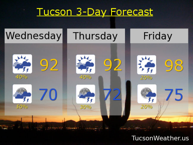
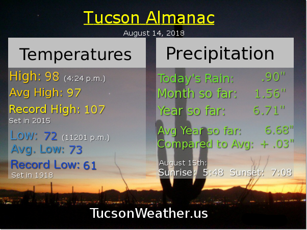
Another somewhat busted forecast yesterday. No wonder people don’t trust weather folk! We did have some morning showers across the metro, bur after that, nada. What happened? Sinking air once again the culprit. Once a disturbance moved through in the morning, sinking air on the back side of said disturbance put the kibosh (kibosh I tell you) on further development despite the National Weather Service hanging on to a 40% chance last night. Sigh. I’ll give News 4 Tucson Meteorologist Jeff Beamish credit. He nailed it on his Noon show! So what about today? Let’s take a stab at it! LOTS of moisture in place. Cloud cover too with a few light showers already this morning (half the calories of our regular showers). Another disturbance headed our way with just a little bit of heating through the cloud cover should be enough to get storms going this afternoon. Heavy rain possible too with all that juicy air in place. We’ll see! Mostly cloudy today with a 50% chance for showers and storms and a high near 90. Mostly cloudy tonight with a 30% chance and a low in the low 70s.

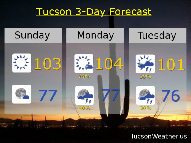
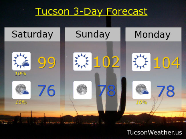
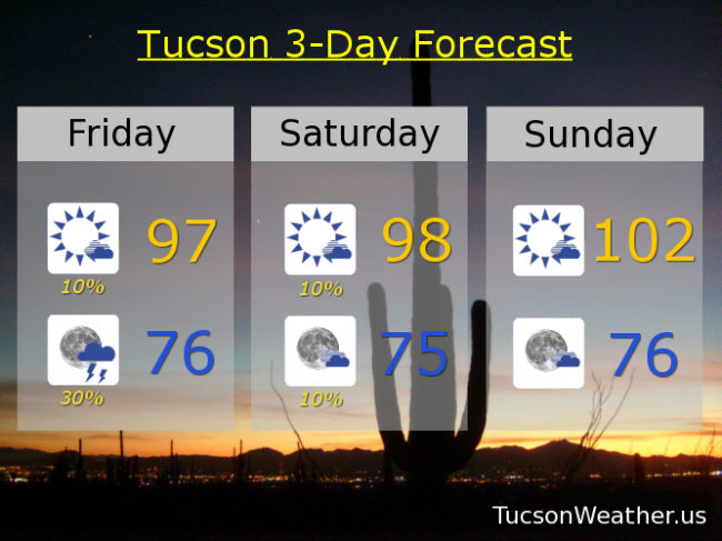
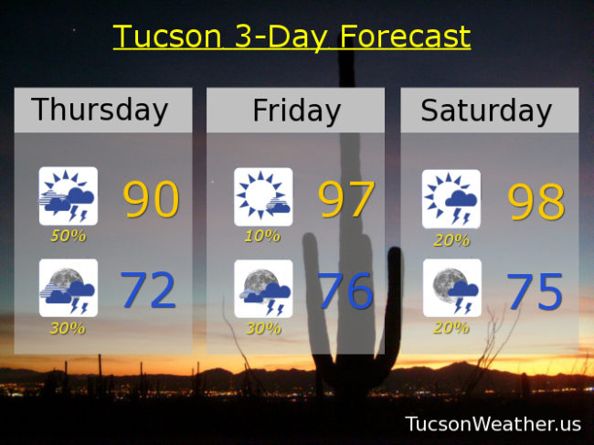
High pressure moving back our way for drier air, more sunshine, warmer temperatures, but still a slight chance for storms (except Sunday). 10%/30% tomorrow upper 90s. 20%/20% Saturday upper 90s. Mostly sunny Sunday 101ish. 20%/20% Monday 100. 20%/10% Tuesday 100. 10% Wednesday 100.

Forecast for Wednesday, August 15, 2018

Sounds like it was a rockin’ night last night! I don’t know. I was asleep 🙂 I do know that there was a Severe Thunderstorm Warning issued last night a little after 11:00. No evidence of rain here in southern Oro Valley and no reports of actual severe weather. However. The airport picked up .90″ inches, so some of you had a good soaking! We do it again today through tomorrow night sans the severe. Soupy air with a disturbance in the force moving through and we can expect plenty of storm activity with locally heavy rain. Lots of cloud cover too, so highs not so high for this time of year in the low 90s today and tomorrow. Viva Monsoon 2018!

Drying out and warming up as we head into the weekend (boo) with upper 90s Friday and a 20% chance for storms (so not zero). Mostly sunny 20%/30% Saturday upper 90s. Upper 90s Sunday with just a 10% chance in the evening. 10%/20% Monday near 100ish. 20% Tuesday 99.