Forecast for Friday, August 24, 2018

It’s Friiidaaay!!!

A FLASH FLOOD WATCH is in effect today from 11:00 this morning until Midnight tonight. So. Much. Moisture. Plus an inverted trough AND another upper low heading our way all adding up to what should be numerous storms today. Some storms will be capable of dropping 1-2 inches of rain (or more) in a short amount of time. We’ll see. We make fun of the jinx that often happens when the Weather Service issues a Flash Flood Watch. Yesterday was off to a promising start and then storms evaporated in the Metro as soon as the watch was issued! Still, flooding occurred in Nogales, near Sierra Vista, Douglas and more, so they weren’t wrong. Will Tucson see flooding rains today/tonight? It looks like a distinct possibility, so just remember to enjoy Monsoon 2018 responsibly. Don’t drive through running water and you should be good! I know you know that, but it’s worth mentioning because we at Tucson Weather care about you! ❤️ Viva Monsoon 2018!

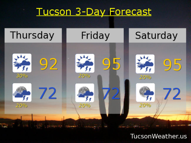
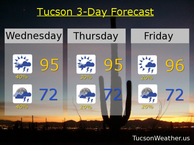
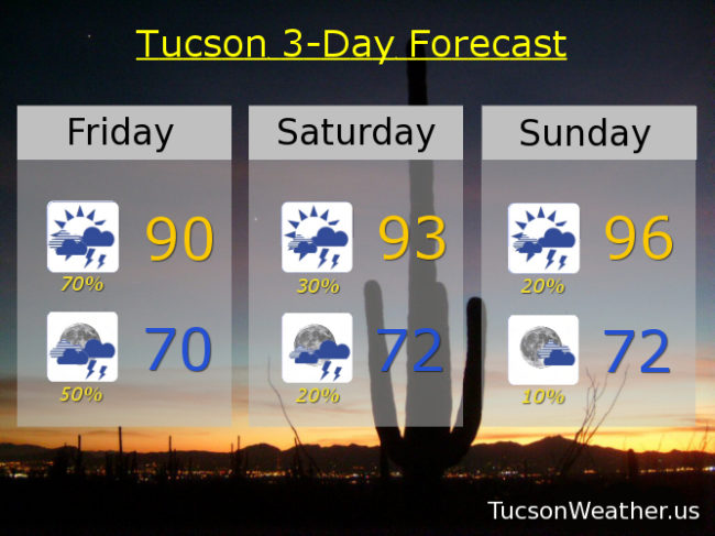
70% chance for storms today, some with heavy rainfall, and a high of only 90! 70 by tomorrow morning with a 50% chance for storms tonight. Again some with heavy rain possible.

Moisture and instability will be with us into tomorrow so a 30% chance for storms and a high near 93.

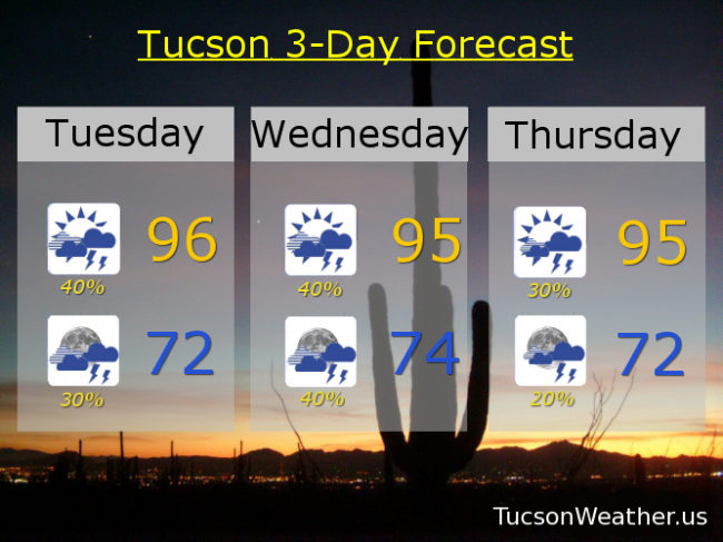
We start to dry out Sunday as we will be in a more westerly flow. A 20% chance for storms, but a better chance to our east. Sunday’s high in the mid 90s.

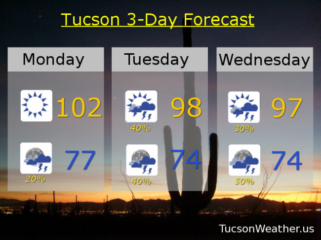
Drying out more Monday with a 10% chance upper 90s. Mostly sunny Tuesday and Wednesday near 100ish. Sunny Thursday 101.

Forecast for Thursday, August 23, 2018

Why did the trees cross the road? Microburst. That’s what happened around Old Father and Thornydale yesterday afternoon. Monsoon 2018 was rockin’ it in Marana and Oro Valley with 1 to 3 inches of rain and even some hail. Not everyone got soaked though. It rained at my apartment in southern OV but no where near an inch. The airport picked up .09″. I hope there was rain where you live. Viva Monsoon 2018! Maybe she does love us after all.

Let’s try it again this afternoon/evening! Lots of moisture still with us. If we can manage enough sunshine this morning we should be off and running this afternoon. Of course not everyone will get storms, but those that do could receive locally heavy rainfall. Low 90s this afternoon and low 70s by tomorrow morning.

Scattered storms continue through the weekend with drying expected next week. 20%/20% tomorrow and Saturday mid 90s. 20%/20% Sunday upper 90s. 10%/10% Monday upper 90s. 10% Tuesday 100ish. Sunny 100 Wednesday.

Forecast for Wednesday, August 22, 2018

Another disappointing Monsoon 2018 afternoon yesterday as morning showers and clouds put the kibosh on afternoon/evening storms. Today’s the day! (unless it isn’t) Rich moisture and lots of morning Sun should (should) lead to afternoon storms with locally heavy rainfall possible. Hopefully our 40% chance becomes reality near you!

30% chance for storms tomorrow with a high in the mid 90s. 20% Friday mid 90s. 20% Saturday and Sunday upper 90s. 10% Monday upper 90s. 10% Tuesday 100ish.

Forecast for Tuesday, August 21, 2018

Welcome back Monsoon 2018! We missed you and of course we’ll take you back. All is forgiven. Now. Show us what you are capable of! Last night was a good start. Tina says in the FB comments that Corona de Tucson got some good rains yesterday. Also the Foothills had a nice storm drift off the Catalina’s in the early evening. Then it was the west. A large are of showers and storms formed and persisted until after dark. Viva Monsoon 2018!

Let’s do it again today shall we? The thinking is that storms will form first to our east where they are likely to see more sunshine earlier. Outflow winds from those storms plus later heating in and near the Metro should have scattered storms firing by evening. Some may linger into the overnight hours. With high pressure back to our east we are in a favorable position for a long fetch of moisture for a good chance for afternoon and evening storms through Thursday! Hopefully near you. Highs in the mid 90s and lows in the low to mid 70s.

We may slow “things” down a little bit by late week into the weekend. Still, there is a chance. 20%/20% Friday 94ish. 20%/20% Saturday, Sunday and Monday mid 90s.

Forecast for Monday, August 20, 2018

While Monsoon 2018 is gallivanting down in Mexico we are left to bake in the Sun. Still, only 101 yesterday, so not all that bad. 102 today before our wayward friend returns. High pressure moving to our east will put us in a southerly flow pushing lots of Monsoon moisture back our way! Even some instability to spark some storminess! I know. You’ll believe it when you see it, but the forecast is looking great for tomorrow and Wednesday. Monsoon 2018 may even surprise us with a storm or two tonight! Hopefully near you.

Partly sunny tomorrow with a 40% chance for storms and a high near 98ish. 40% chance tomorrow night with a low in the mid 70s. 30%/50% Wednesday upper 90s. 30%/30% Thursday mid 90s. 20%/20% Friday, Saturday and Sunday mid 90s.