Forecast for Wednesday, August 29, 2018

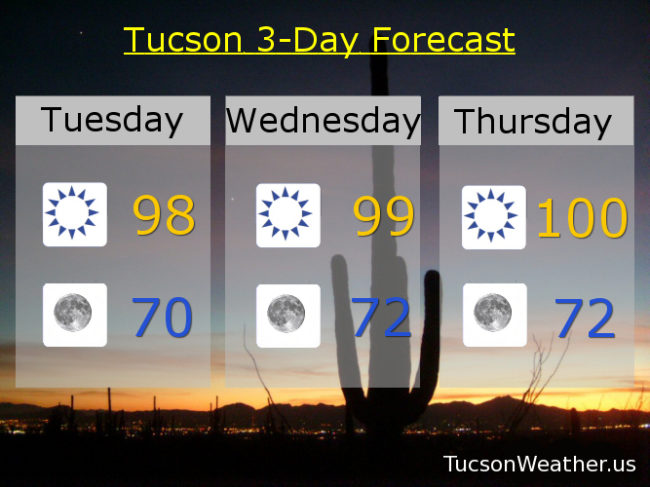
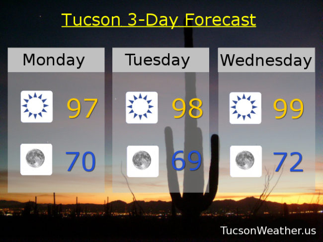
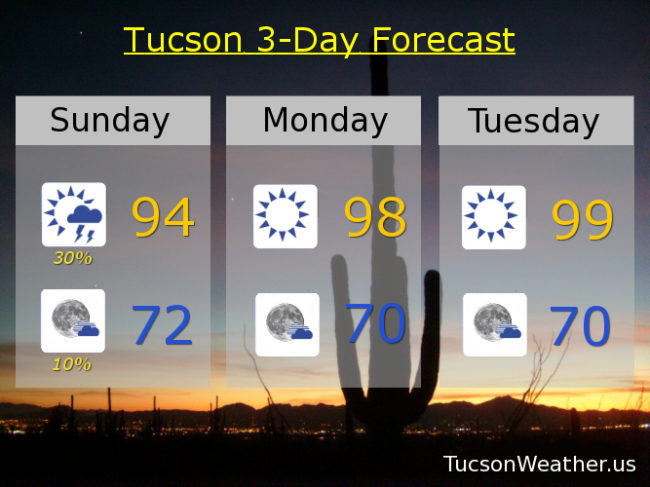
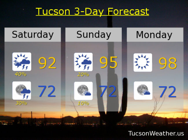
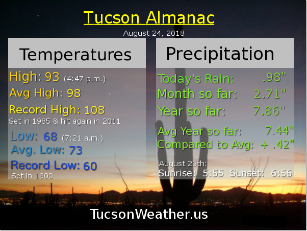
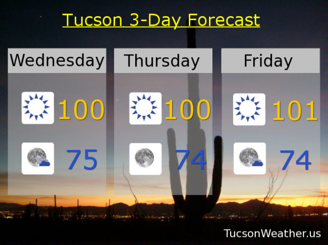
“99. I’ve been waiting so long. For 99. Where did we go wrong. Oh 99. I love you!” I mean as long as the humidity is reasonably low. Yesterday was that day! Amazing again on the deck this morning and the coffee is always good. Highs near 100 today and tomorrow with a slight chance for storms along the international border. Monsoon 2018 isn’t that far away and she’s planning her return for this weekend if the forecast comes true. One computer model still keeps us dry, so we’ll see how it plays out. 101ish Friday. 20%/20% Saturday 98. 30%/30% Sunday 96. 20%/20% Labor Day 96. 10% Tuesday 96. Stay tuned!

Forecast for Tuesday, August 28, 2018

Gorgeous on the deck this morning! Low 70s and a light wind. Near 70 to low 70s in our morning forecast for the next few days equals a great way to start the day outside with that cup of coffee!

“They say our love won’t pay the rent. But you know our money’s always spent. Babe. I got you babe!” The rest of the forecast is like groundhog day except we don’t have groundhogs here (do we?). We’ll call it prairie dog days with highs in the upper 90s to near 100 through Thursday. Monsoon 2018 is stalking us from just south of the border. Will she return this weekend? Computer models disagree with one dry and another with scattered storms. The National Weather Service is leaning toward the latter and who are we to argue? We’ll go sunny Friday near 101ish with a 10% chance for a storm Friday night low 70s. 20%/20% Saturday 98. 30%/30% Sunday 96. 20% Labor Day 95. Stay tuned!

Forecast for Monday, August 27, 2018

Cue the Three Degrees, “When Will I See You Again”, the Cascades, “Rhythm of the Rain”, and Chicago. Sing it with me… “Everybody needs a little time away. I heard her say. From each other…” All that to say (sing) Monsoon 2018 is taking the week off. Who authorized that?! Drier air working its way in pushing Monsoon out. Highs getting a little warmer each day, but dry air cools more quickly under the stars. Morning’s look terrific for your coffee out on the deck. Monsoon returns to us this weekend. At least, that’s what she said when she left… Stay tuned!

Sunny through Friday with highs in the upper 90s through Wednesday. 100ish Thursday. 101 Friday. Mostly sunny Saturday with a 20%/30% chance for storms 100. 30% Sunday 99.

Forecast for Sunday, August 26, 2018

It was a beautiful Saturday! High of only 92. Lots of sunshine. But. The storm chances never became reality, so there’s that. One last chance for Monsoon 2018 to show off before she takes a break. Moisture in place today, but a westerly flow will take over and dry us out starting tonight. Monsoon 2018 may return to us by next weekend if we play our cards right. One cool thing about drier air is cooler mornings! Look at those lows near 70. Pretty perfect.

Mostly sunny today with a 30% chance for scattered storms this afternoon and a high in the mid 90s. 10% chance for storms this evening then partly cloudy with a low in the low 70s.

Sunny tomorrow, Tuesday and Wednesday upper 90s. Near 100ish Thursday. 101 Friday. 10% Saturday 100. Enjoy!

Forecast for Saturday, August 25, 2018

70 degrees and amazing on the deck this morning! That first cup of coffee even more satisfying after an amazing light show last night. Most of the Metro getting much deserved and needed rain with the airport picking up nearly an inch of rain (.98″). A big thanx to all who washed their car and left the patio furniture out yesterday! Moisture hanging around for one more day before we start to dry out. Scattered storms possible this afternoon and evening with locally heavy rain possible as one more disturbance moves our way out of Mexico (thank you Mexico!) Low 90s today and low 70s tonight. Viva Monsoon 2018!

Drier tomorrow but still a chance for an isolated storm or three, hopefully near you, with a high in the mid 90s. A more westerly flow will push out our moisture and bring sunshine and warmer temperatures next week. Upper 90s Monday and Tuesday. 100ish Wednesday and Thursday. 101 Friday.