Monthly Archives: August 2018

Forecast for Saturday, August 11, 2018

That’s what happens when you treat your girl right. She showers you with storms and small hail! If Monsoon 2018 ain’t happy, ain’t nobody happy. Not as much showering us with storms today with a bit of drying in the upper levels of the atmosphere, but still an afternoon of excitement headed our way with the fun lasting into the evening.  Tomorrow looks even better as the drier air retreats.  High pressure nosing into our business a bit Monday and Tuesday will slow down storms some, but we shouldn’t be left completely high and dry.  Storm chances look really good Wednesday night/Thursday as moisture increases again and a disturbance in the force is expected to invade from Mexico. We love you Monsoon 2018! Don’t ever leave!

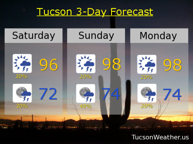
Mostly sunny today with scattered afternoon and evening storms and a high near 96. Low in the low 70s.

Mostly sunny tomorrow with a 20%/40% chance for storms 98ish. 20%/20% Monday 98. 10%/20% Tuesday 98. 20%/30% Wednesday mid 90s. 30%/20% Thursday low 90s. 30% Friday mid 90s.

Forecast for Friday, August 10, 2018

Showers overnight with a bulls eye of nearly 2″ in Marana! A few hundredths at the airport. Hopefully some near you! Lingering showers in the area even as I type at 6:30. Dewpoint is 67, so way up there. Looks like another good chance for storms by tonight. Activity forming in the White Mountains first, moving to the SW as the afternoon and evening progresses. 40% chance for storms this afternoon and 50% tonight. Viva Monsoon 2018! Storm chances fade a bit by Sunday into early next week, but still a 20% to 30% chance for scattered afternoon and evening storms. Chances ramp back up mid week and for the foreseeable future thereafter! Looks like a good Monsoon August is shaping up, at least in theory. Hopefully it will translate into real life! Of course we’ll keep you posted.

Becoming partly sunny today with a 40% chance for afternoon storms and a 50% chance tonight. Some storms with locally heavy rainfall possible. High 94, low 74.

Partly sunny tomorrow with a 30% chance for afternoon and evening storms mid 90s. Partly cloudy Sunday 20%/30% chance for storms upper 90s. 20%/20% Monday 98ish. 20%/20% Tuesday 99. 30%/30% Wednesday upper 90s. 30% Thursday mid 90s.

Forecast for Thursday, August 9, 2018

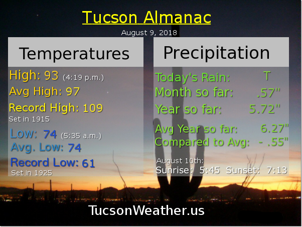
Viva Monsoon 2018! Storms in the area around 10:00 last night, hopefully near you. A decent light show to my north as a storm formed briefly over the OV, but no rain for me on the south side of our little burb. Lather, rinse, repeat into the weekend as we are now in an active Monsoon pattern.

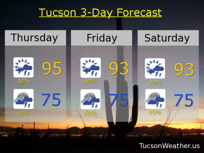
Easterly flow across the area with tons of moisture in place. Storms should form closer to the Metro this afternoon and drift in from the east for potentially an earlier start today. Locally heavy rainfall is possible with some of these storms and maybe some blowing dust for the usual areas. High around 95ish. Mostly cloudy tonight with scattered storms into the night with a low near 75.

Partly sunny tomorrow with a 40% chance for storms and a high in the mid 90s. 50% chance for storms tomorrow night mid 70s. 30%/40% Saturday low 90s. 20%/30% Sunday upper 90s. 20%/20% Monday, Tuesday and Wednesday upper 90s.

Forecast for Wednesday, August 8, 2018

Welcome back Monsoon 2018! .26″ at the airport adding to our totals. That was fun last night, although I got skunked here in southern Oro Valley. I know how many of you feel when the OV was getting soaked and many of you were being left out. It’s like Monsoon is going on a date with all your friends and you have to watch from across town. But when Monsoon goes out with us again all is forgiven! We hug and kiss her and beg her not to leave. Looks like we have a date tonight. I can’t wait!

Day to day Monsoon activity tough to call. Computer models originally saying prime time would be tonight and Thursday morning now saying Thursday night and Friday. Some models are saying we quiet down a bit next week, but one model saying not so fast. Dewpoints in the mid 60s this morning so lots of moisture in place. Looks like a good chance for scattered afternoon and evening storms into the weekend and perhaps beyond. Viva Monsoon 2018!

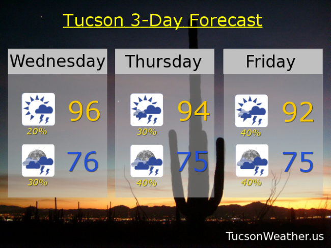
Mostly sunny today with a chance for storms this afternoon and a high near 96. Mostly cloudy tonight with a better chance for storms and a low in the mid 70s.

Partly sunny tomorrow and mostly cloudy tomorrow night. 30%/40% 94ish. 40%/40% Friday low 90s. 30%/30% Saturday mid 90s. 20%/30% Sunday and Monday mid 90s. 20% Tuesday mid 90s.

Forecast for Tuesday, August 7, 2018

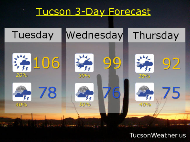
I had a weird dream that my cell phone woke me up with an EXCESSIVE HEAT WARNING warning at 3:00 a.m. Then I woke up and saw that it wasn’t a nightmare, it was true! Be warned. There will be excessive heat. Yesterday we tied the record high of 109. A couple of stray storms made it’s way across town last night, hopefully near you! The airport picked up .05″ which beats a swift kick (don’t ask me how I know that). Moisture is increasing across the area, so today’s expected high of 106 will be a bit uncomfortable. The good news is storms should fire earlier today and by this evening more of us will have a chance of getting wet. Tonight’s low in the upper 70s.

High pressure moving northward with an inverted trough riding our way from the east. Lots of moisture including a couple of hurricanes south of Baja California that will help push more our way. It all adds up to what should be an active week for Monsoon 2018! Early indications are that prime time will be tomorrow night and storm chances remain good into the weekend!

Partly sunny tomorrow with a 30% chance for storms and a high near 99ish. Mostly cloudy tomorrow night with a 50% chance for storms mid 70s. 30%/40% Thursday low 90s. 20%/40% Friday mid 90s. 30%/40% Saturday mid 90s, 20%/30% Sunday mid 90s. 20% Monday mid 90s.