
Monthly Archives: June 2018
Forecast for Thursday, June 14, 2018
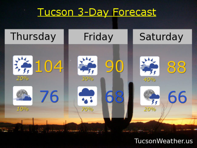
Let’s get this party started! Monsoon 2018 officially starts tomorrow, but we may see a bit of action today. Dewpoints in the 30s this morning combined with off and on clouds overnight has given us a rather warm start to the day. 80 has been the low so far and that will probably be it. The better news is that moisture will increase throughout the day thanx to our southerly flow which may lead to a few storms this afternoon/evening in the Metro, hopefully near you! Storms that form may generate gusty winds and even blowing dust, so there’s that. Not as hot as yesterday’s 106, but still kinda hot with a high near 104.
Mostly cloudy tonight with a slight chance for a lingering storm and a low in the mid 70s.
Here’s comes the moisture from the remnants of Hurricane Bud tomorrow! Moisture levels near records for mid June by afternoon/evening. Scattered afternoon and evening storms with a high near 90. As the deeper moisture moves in tomorrow night we will shift to more of just plain rain showers with maybe a storm. Some of the showers tomorrow and tomorrow night may be on the heavy side. Since Bud’s main track is now expected to veer into SW New Mexico the best chance for heavy rain will be Santa Cruz and Cochise county, but Tucson still may get in on some heavy showers. Just be aware that areas of flash flooding may still be possible. Tucson is expecting a half inch to an inch of much needed rain. Certainly some locally higher amounts may occur.
Rain is likely Friday night into Saturday morning. Again, locally heavy rain is possible. Moisture hangs on through Saturday with mostly cloudy skies and a chance for afternoon and evening storms with a high in the upper 80s.
A trough to our north will push the moisture outta here on Sunday with sunshine and a high in the mid 90s. Upper 90s Monday and Tuesday. Near 100 Wednesday. Viva Monsoon 2018!
Almanac for Wednesday, June 13, 2018

Forecast for Wednesday, June 13, 2018
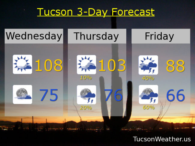
High pressure centered in New Mexico. Close enough for a hot day in Tucson and hot enough for an EXCESSIVE HEAT WARNING. Be warned, there will be excessive heat. Some mid and high clouds around will likely save us from the pain of hitting the record of 110, so there’s that. Also, enough moisture moving in for a slight chance of a storm or two in the mountains.
Call it partly cloudy tonight and warm as moisture from the south continues to increase. That’ll keep the low not so low in the mid 70s.
Deeper moisture moving in tomorrow. A slight chance for storms in the afternoon and a bit better chance for storms in the evening with a high near 103ish. Storms that do form could have gusty winds and blowing dust.
Even deeper moisture moving in on Friday from the remnants of what was once Hurricane Bud. Friday’s forecast is still kind of tricky. Will the clouds move in too early for a cloudy, humid, day with no real trigger for storms to form? Or will there be enough sunshine in the morning to give us a good chance for storms and locally heavy rainfall. Right now the official forecast is for the latter. Let’s hope so. We need it! Either way a high only in the upper 80s!
Good chance for storms continues Saturday with a high in the upper 80s. Drying out Sunday low 90s. Upper 90s Monday. Near 100 Tuesday. Viva Monsoon 2018!
Almanac for Tuesday, June 12, 2018
Forecast for Tuesday, June 12, 2018
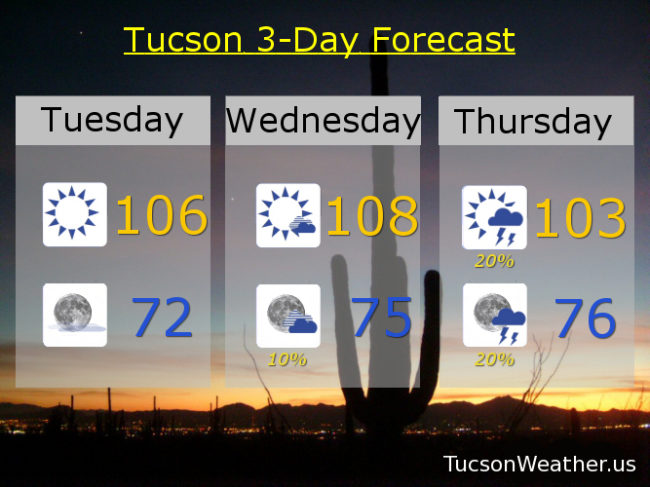
“Things” are getting interesting indeed! High pressure building in today and tomorrow for downright hot weather. I don’t really get too cranky until we hit 110. We are getting annoyingly close with a forecast high tomorrow of 108. Along with that comes an EXCESSIVE HEAT WARNING, so be warned, tomorrow will have excessive heat.
Then the advertised moisture increase starts to arrive with a slight chance for isolated storms perhaps as early as tomorrow evening. Better slight chances Thursday with a high near 103.
Friday looks to be prime time and perhaps into Saturday. Moisture from the remnants of what is now a very strong Hurricane Bud is forecast to surge in here late Thursday into Friday and could lead to isolated severe storms Friday afternoon/evening as well as some locally heavy rainfall! Friday’s high in the low 90s. There is a danger that we’ll get too much moisture and we could end up with cloudy skies and stable conditions with nothing really to get storms going. I don’t think that will be the case Friday, but it’s worth keeping in the back of your mind to avoid the resulting disappointment, depression and emotional overeating should that occur. Assuming it doesn’t, we’ll keep storm chances going Saturday with mostly cloudy skies, some heavy rain possible, and high in the upper 80s!
We dry out Sunday and Monday with highs back in the mid 90s.
Almanac for Monday, June 11, 2018

Forecast for Monday, June 11, 2018
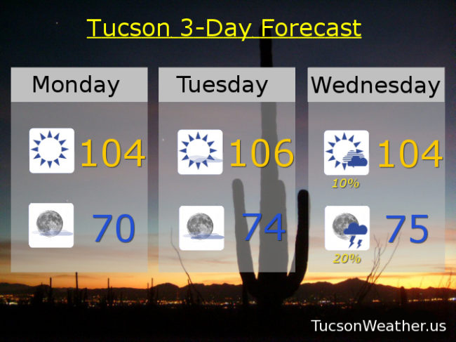
The dry westerly flow dried as out as expected yesterday with a high of 104 and a breeze. Kinda felt like a hot blow dryer out there! Great conditions to tease that Farrah Fawcett hair! More of the same today with perhaps a bit less of a breeze. High pressure will start to reform over New Mexico/west Texas bringing us a southerly flow and a steady increase of moisture this week. Hurricane Bud off the Mexican coast is still expected to help the cause as it moves toward the Baja California spur. Slight storm chances in the official forecast as early as Wednesday with the best chances on Friday perhaps into Saturday. We’ll keep you posted as we get closer. Stay tuned!
Sunny today with a high near 104.
Mostly clear tonight with a low near 70.
Mostly sunny tomorrow 106ish. Slight chance for storms Wednesday afternoon and evening 104. Slight chance for storms Thursday afternoon/evening 102. Scattered storms possible Friday mid 90s. Scattered storms possible Saturday low 90s. Isolated storms possible Sunday mid 90s.
Almanac for Sunday, June 10, 2018

Forecast for Sunday, June 10, 2018
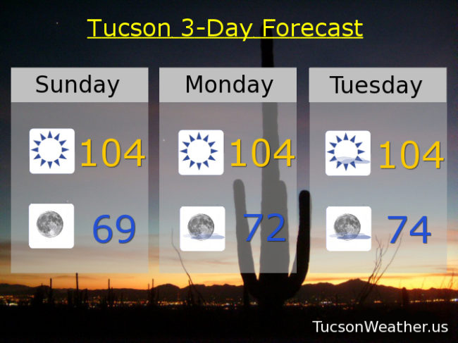
105 yesterday with a few storms about, especially near Sierra Vista. One shower almost (almost) dropped a few drops on the Tucson International Airport! Almost. Drying out today and tomorrow as a system well to our north brings a westerly flow into Arizona. That will keep the deep moisture just to our south in Mexico. It will also keep us on the kinda hot side the next few days.
High pressure re-consolidates to our east by Tuesday and the resulting southerly flow will start to increase our moisture. In addition, Tropical Storm Bud (soon to be Hurricane Bud) will move toward the southern spur of Baja California. That will aid a moisture surge up the Gulf of California into southern Arizona. It looks like all the ingredients are coming together for a kick start of Monsoon 2018 for Tucson by mid to late week! The official start of Monsoon (June 15th) is Friday and it looks like we may have record, or close to record, moisture levels for any June day ever! That could work against us though. If we don’t get enough heating to spark storms we may end up with just a really humid day. Having said that, storm chances start Wednesday, increase Thursday, really ramp up Friday and linger into Saturday. That kind of deep moisture is hard to hold onto this early in the season, so expect some drying by next week. Viva Monsoon 2018! Let’s do this!
Sunny today and tomorrow with a high near 104ish. Low tomorrow morning in the upper 60s.
Mostly sunny Tuesday 104. 10% chance for isolated storms Wednesday 103. 20% chance for storms Thursday near 100. 40% chance for storms Friday mid 90s. 30% chance for storms Saturday low 90s.