Mike Mike Mike Mike Mike. What day is it Mike? It’s the beginning of a warming trend, that’s what day it is. But first…
Yes, it’s a HARD FREEZE WARNING until 9:00 this morning. It’s 30 at 5:00 a.m., so it could be worse. And it may. It’s a matter of degrees. Perhaps a few fewer of those between now and sunrise, so there’s that. 50ish by this afternoon, so we are still the cool kids. 😎 Another HARD FREEZE WARNING tonight/tomorrow morning with a low in the upper 20s.
Sunny and warmer tomorrow with a high in the upper 50s. Upper 60s Friday. The weekend looks great! Mid 70s with Sunshine on Your Should Saturday and Sunday. Our next storm approacheth with a chance for showers Monday and breezy with a high in the upper 60s. A better chance for showers Tuesday near 60ish. Stay tuned and stay warm!
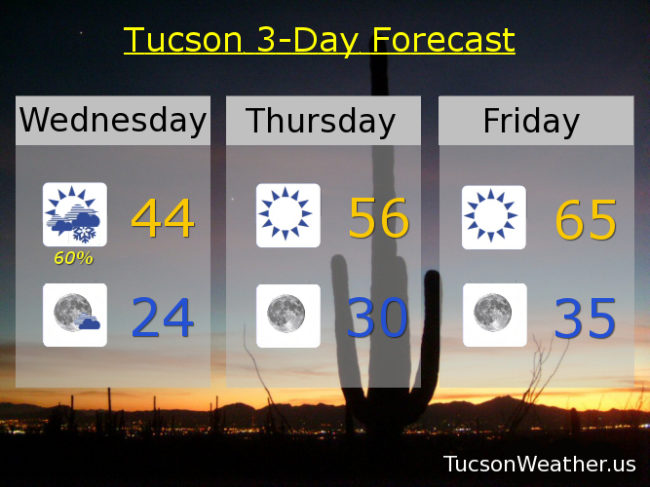
Due to lack of interest, this morning’s HARD FREEZE WARNING has been cancelled. Actually it’s the cloud cover. As the “heat” tries to escape into the space (echo: space space space) the clouds act as a blanket to keep the “heat” in. So. We are near 40ish to start today. We’ll keep it on the cool side with a high this afternoon only in the upper 40s.
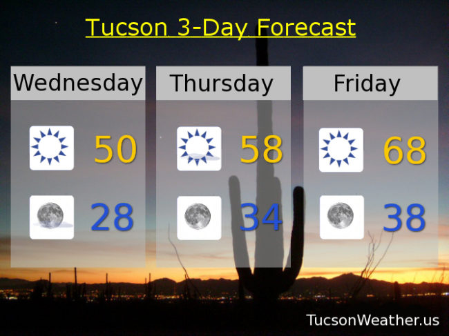
A HARD FREEZE WARNING remains in effect for tonight/tomorrow morning. Please for the love of all that is right and good, let the teenagers sleep inside tonight. Low near 25 to start tomorrow. Wednesday’s high near 50ish. 60ish Thursday. Upper 60s Friday. Mid 70s Saturday and Sunday! A slight chance for rain and breezy Monday low 70s. Enjoy!
Well that deescalated quickly! We knew this next storm was moisture starved, but this is looking pretty dry. Maybe an inch or two of snow will get squeezed out in the mountains. Here in the lowlands maybe a bit of light rain (yes, half the calories of our regular rain) but it’s looking like that’s about it. I’m sorry snow lovers. The timing of the showers, if we have any, means we are looking at a rain non-event. Bummer. We are expecting snow here in Lubbock on Wednesday! If it happens I’ll share a pic or three. It’s going to get COLD in the old Pueblo. HARD FREEZE WARNINGS for tonight/tomorrow morning and tomorrow night/Tuesday morning. I’ll be just as cold Wednesday morning but no warning. Probably because everything will be frozen dead by then! I saved the worsest for last. The wind. If you have hatches batten them down! Details in 3… 2…
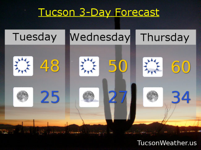
Mostly sunny today and windy. West winds 20-25 mph gusting to near 40! A slight chance for a shower with a high in the mid 60s. slight chance for rain tonight before midnight. Winds relaxing with a HARD FREEZE WARNING and a low near 30ish. Sunny and not warm tomorrow upper 40s. HARD FREEZE WARNING tomorrow night mid 20s. Sunny near 50ish Wednesday. 60ish Thursday. Upper 60s Friday. Mid 70s Saturday. Low 70s Sunday. Enjoy?
In case you missed it. I arrived in Lubbock, Texas safely with all of my wordly possessions at about 1:00 a.m. this morning Texas time. I also don’t know if you know I was a morning TV Weatherdude here from 1994 to 2002. So I’m back in Lubbock on Groundhog Day. Irony!
Exciting times ahead in the Tucson Weather Forecast. Winter is returning! (movie announcer voice, “this time it’s personal”) A cold, strong, and quick hitting storm is fixin’ to move through tomorrow into tomorrow night. A chance for rain changing to snow showers tomorrow night with a mix in the transition. It will be COLD! A HARD FREEZE WARNING is in effect tomorrow night/Tuesday Morning and Tuesday Night/Wednesday morning. People, pipes, pets, plants, and other things that start with p that are susceptible to freeze that I can’t think of right now (feel free to add yours in the comments) The quadrillion dollar question. How much snow will we get in town? Unfortunately not a lot. The system won’t have a lot of moisture to work with so little to no accumulations expected, but let’s root for the Chiefs (sorry, I digress) and more than a covering of snow! Let’s outline the (weather) excitement, shall we? Yes let’s!
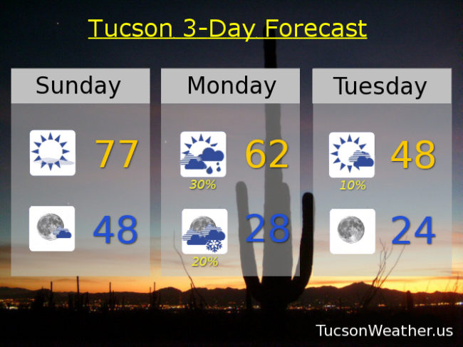
A Super Sunday today with sunshine. A bit breezy with SW winds 5-15 mph and a high in the high 70s! Mostly clear tonight upper 40s.
Partly cloudy and breezy fo sheezy tomorrow (windy?) with south winds 15-25 mph gusting to 35. A chance for showers by afternoon with a high in the low 60s.
A slight chance for rain showers before 10:00 tomorrow night transitioning to a slight chance for snow showers. WNW winds 5-15 mph becoming south. HARD FREEZE WARNING with a low in the upper 20s.
The HARD FREEZE WARNING expires this morning at 8:00, but not before we experience a hard freeze. It’s 31 out there right now (4:37 a.m. what am I doing up since before 4:00 a.m.? great question!) and we will likely fall a few more degrees before the Sun comes up at 7:01. That heavy coat of yours is getting some use this Winter! High temperatures staying well below the average of 69 for this time of year. And…
You might want to sit down for this forecast. A major Winter storm is heading our way. Let’s just go through the snowfall amounts that are in Summerhaven’s official from the National Weather Service forecast. A WINTER STORM WARNING is in effect from 5:00 a.m. tomorrow morning until 5:00 p.m. Friday. Snow, heavy at times, tomorrow with 10-14 inches of snow accumulation possible. Snow, heavy at times, tomorrow night with 14-20 inches of ADDITIONAL snow possible. Snow, heavy at times, Friday with 8 to 12 inches of new snow possible. Add another inch or two perhaps Friday night!!! So. Doing some simple math… that adds up to 33″-48″ (basically three to four feet!) of snow for Summerhaven. WOW! is all I can say. Also. Do you know someone who might let me stay up there in their cabin??? 😃
Meanwhile, back down here at the ranch, we are looking at increasing clouds tonight with a 100% chance for rain tomorrow, tomorrow night and Friday. Rain, heavy at times, with three-quarters of an inch to an inch and a half possible from this storm. Snow levels starting around 5,000 feet tomorrow dropping down to 2,000 – 3,000 feet before the storm is done late Friday night into early Saturday morning. Oracle could see 6″-12″ of snow! Tucson (yes, Tucson) could (maybe!) see a trace to 3 inches of snow! Vail, Corona de Tucson, Catalina, Saddlebrooke will likely have some snowman building snowfall. Tucson maybe! Still a couple dayz out. Stay tuned!!!
The Sun returns by the weekend and we start to warm up some. Still a few degrees below average by Tuesday.
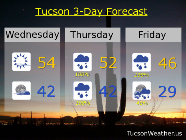
Sunny today with a high in the mid 50s. Increasing clouds tonight low 40s. Showers likely tomorrow morning with rain in the afternoon and breezy with a high in the low 50s. Rain, heavy at times, tomorrow night low 40s. Rain, heavy at times, Friday mid 40s. A chance for rain showers Friday night before midnight then a slight chance for rain and snow showers becoming partly cloudy upper 20s. Sunny Saturday low 50s. Near 60ish Sunday. Low 60s Monday. Mid 60s Tuesday. Enjoy!
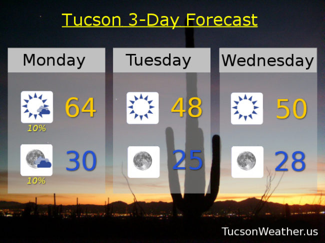
A HARD FREEZE WARNING in effect tonight from 11:00 p.m. until 8:00 a.m. tomorrow morning. Please. For the sake of all that is right and good let the teenagers sleep inside tonight! Also. Tonight’s record low is 25 set in 1955. Do we dare get that cold? The forecast is close at 27. We’ll see. We are between storms today and tomorrow. A lot of sunshine, but not very warm. Especially when you consider the average high for this time of year is 69. We’ll be at least 15 degrees colder than that through Saturday!
The next storm looks cold and very wet. A foot or three of snow for the mountains possible Thursday through Friday night! A WINTER STORM WATCH is in effect for Summerhaven from Thursday morning at 11:00 until Friday evening at 5:00. Three-quarters to an inch and a half of rain perhaps for us lowlanders. Also. Maybe (maybe) some snow mixed in in the Metro Friday night/Saturday morning. That didn’t really pan out last night, so we’ll see.
The Sun returns this weekend with a high on Sunday near 60ish! Still below average, but some rays of hope. (see what I did there?)
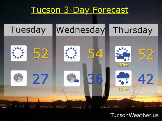
Sunny and cool today with a high in the low 50s. Clear and cold tonight with a low in the upper 20s. Sunny mid 50s tomorrow. Showers and breezy Thursday low 50s. Rain, heavy at times, Thursday night and Friday. Friday’s high in the upper 40s. A chance for rain and snow showers Friday night with a low in the upper 20s. Sunny Saturday low 50s. Sunny Sunday 60ish. Mid 60s Monday.
The storm has arriveth! Showers currently moving through the Metro with snow falling above 5,000 feet. A WINTER WEATHER ADVISORY remains in effect until 11:00 this morning for Summerhaven. Perhaps an additional inch or two of snow expected there this morning. Rain showers likely in town this morning with clearing skies this afternoon and perhaps some lingering showers. With a cold front blowing through Tucson expect highs only in the low 50s. Mostly clear skies and cold air moving in behind the storm means COLD temperatures tonight. A HARD FREEZE WARNING from 1:00 am until 9:00 am tomorrow morning with lows in the upper 20s. Be warned. It’s gonna freeze hard. I don’t know. You might want to let the teenagers sleep inside tonight. Also pets, pipes, plants, people. Chilly again tomorrow (mmm chili) with sunshine. Warming up to near average this weekend. Stay tuned!
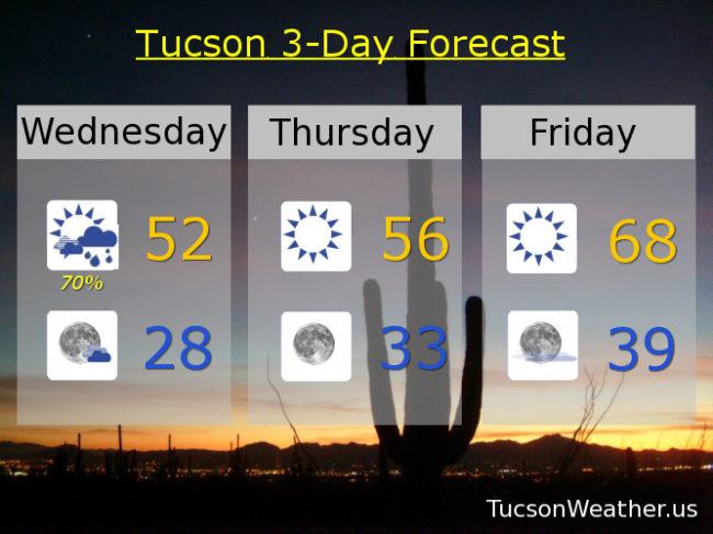
Showers likely before Noon today with isolated showers possible this afternoon. Clearing skies with a high in the low 50s. Clear and cold tonight with a low near 28ish. Sunny mid 50s tomorrow. Upper 60s Friday and Saturday. Partly sunny Sunday mid 60s. Mostly sunny Monday mid 60s. Partly sunny Tuesday mid 60s. Enjoy!
The HARD FREEZE WARNING is fixin’ to end at 9:00 this morning and then we can start our warming trend. Mid 20s to start the day is rather brisk, so I imagine that you might welcome some sunshine and relative warmth. If you have snow on the ground it will be going from concrete this morning to mostly gone later today. The exception will be up in the mountains and down here in the shade 😎 Our next storm approacheth Saturday with increasing clouds and rain in here by Saturday night. Snow levels will start high and then fall to around 7,500 feet. As you can see this storm is quite a bit warmer than the last few. It has a lot of moisture to work with too. It could be a good soaking for us valley dwellers. Ski Valley on Mt. Lemmon might add quite a bit to their 40″ base! Storm moves along on Monday and we warm up again Tuesday and Wednesday. As I’ve been showing you on the last few livestreams at least one computer model is hinting that a couple more storms are likely heading our way as we head into mid January. Stay tuned!
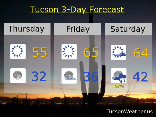
Sunny today with a high in the mid 50s. Clear skies at night near freezing. Mid 60s tomorrow. Partly sunny mid 60s Saturday. 60% chance for rain Saturday night low 40s. 70% Sunday mid 50s. 10% Monday low 60s. Mostly sunny Tuesday and Wednesday upper 60s to near 70ish! Enjoy!
It’s snowing! Again. Not everywhere. For example, the radar shows light snow where I live in southern OV, but I’m not seeing any out the window just yet. I am hearing reports of sticking snow in parts of midtown, and the Foothills. Sahuarita, Corona de Tucson, and Vail all getting light snow (half the calories of our regular snow). Light snow also falling at the airport which makes it official! If you are getting snow this morning please let us know. Snow showers in the forecast through the morning hours and our WINTER WEATHER ADVISORY remains in effect until 9:00 this morning with mainly light accumulations in the Metro. Perhaps up to an inch or two in Vail, Corona de Tucson, and Sahuarita/Green Valley.
Skies start to clear this afternoon/evening with temperatures cratering tonight. HARD FREEZE WARNING from 10:00 p.m. until 9:00 tomorrow morning. 24 for a low. Yeah. COLD.
Then we start a bit of a warming trend before our next storm approacheth. Highs actually close to average for this time of year Friday and Saturday. A good chance for rain and mountain snow Saturday night into Monday. Stay tuned!
Snow showers likely this morning with clearing skies later this afternoon and a high in the mid 40s. Mostly clear tonight with a low in the mid 20s. Sunny mid 50s tomorrow. Mid 60s Friday. Partly sunny mid 60s Saturday. 40% chance for showers Saturday night and a 50% chance Sunday upper 50s. 10% Monday low 60s. Sunny upper 60s Tuesday. Enjoy!
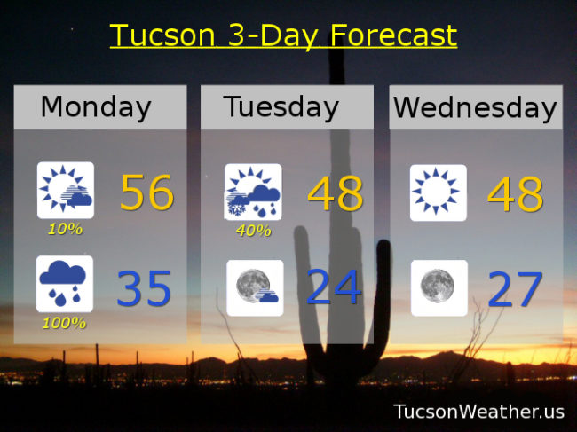
Our winter storm approacheth! Already some winds kicking up out there. It will be a “breezy” day with south winds gusting over 30 mph. Increasing clouds with a slight chance for showers this afternoon even. Rain begins in earnest (and Tucson too) tonight with the National Weather Service giving us a 100% chance for rain! 💯 Rain mixing with or changing to snow New Year’s morning with a WINTER WEATHER ADVISORY in effect above 3,500 feet from 5:00 p.m. tonight until 5:00 p.m. tomorrow night. I’m looking at you Catalina, Vail, and Corona de Tucson! Maybe an inch or so of snow for y’all! What a great way to start the year if we could manage snow showers in and around Tucson tomorrow morning! Meanwhile in the mountains it’s a WINTER STORM WARNING from 2:00 this afternoon until 5:00 p.m. tomorrow. Summerhaven expecting 1 to 2 feet of snow!!!
All of this excitement is followed up by a HARD FREEZE WARNING for the Metro starting tomorrow night at 10:00 p..m. until 9:00 a.m. Wednesday morning. Mid 20s expected! Hopefully no more flies on my hikes. For those of you sick of the cold, take heart. Warming up to near average (mid 60s) by Friday and Saturday. Another Storm in here by the end of the weekend but it looks like snow levels high enough to maybe even melt some mountain snow. Stay tuned!
Increasing clouds and breezy today with south winds 15-25 mph gusting to near 35. 10% chance for showers this afternoon and a high in the mid 50s. 100% chance for showers tonight with snow possible above 3,500 feet and a low in the mid 30s. Scattered rain and snow showers tomorrow morning followed by scattered rain showers with decreasing clouds late and a high in the upper 40s. Mostly clear Tuesday night/Wednesday morning with a low near 24ish! Sunny Wednesday upper 40s. Upper 50s Thursday. Mid 60s Friday and Saturday. 40% Sunday upper 50s. Enjoy!